Historic Preservation:
Ancient Cemeteries and Burial Site Mapping
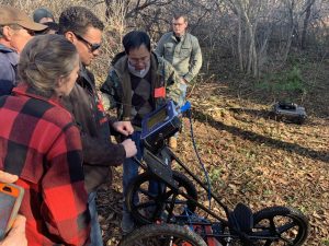
Ground penetrating radar technology is used to assist local historical societies to detect and survey ancient cemeteries and unmarked burial sites in Maine and New Brunswick.
In addition, using GPS/GIS technologies, cemeteries have been mapped and GIS databases have been developed with funding from two Maine Economic Improvement Fund (MEIF) grants. Ten University of Maine at Presque Isle (UMPI) students, along with faculty, performed cemetery data collection and database development, as well as data online publication.One example is Fairmount Cemetery (External Site).