Intro to GIS Mapping micro-credential skills used in western Maine emergency management
A Somerset County emergency management official is modernizing western Maine’s community responses to flooding, by converting damage reports and personal accounts into a sophisticated interactive map.
Sara Bickford, Deputy Director of Somerset County Emergency Management Services, put new technical skills to work after taking Intro to GIS Mapping through the Maine Geospatial Institute and the University of Maine System Micro-Credential Initiative.

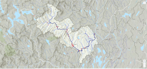
Sara collaborated with local officials in Franklin and Somerset counties to collect data from municipal leaders, farmers, homeowners, and other landowners along the Sandy River Watershed who have been impacted by flooding and erosion. Using mapping tools Survey123 and ArcGIS, she compiled flood data, personal accounts of damage, and contact information to build a data-driven tool that helps visualize impacts for use in meetings, online, and in public communications.
“After completing the Intro to GIS Mapping Micro-Credential, I immediately put my new skills to work,” Sara said. “While planning a series of community forums, our team originally discussed collecting data on paper maps and compiling the information manually. While that traditional approach had worked in the past, I saw an opportunity to modernize the process using the GIS tools now available to us.”
This new method not only streamlined data collection but also allowed her organization to layer and analyze the information in ways that reveal the broader impacts of flooding across the Sandy River Watershed, Sara said.
“The Micro-Credential gave me the confidence and foundational skills to begin presenting data in a way that others can easily understand,” Sara said. “The self-paced format fit well with my busy schedule, and the experience was absolutely worthwhile. I highly recommend this course to anyone interested in GIS or looking for innovative ways to collect and display data in their work.”
The Somerset County Emergency Management Agency works to build a resilient and prepared county by leading coordinated efforts in mitigation, preparedness, response, and recovery for the safety and well-being of all 51,000 residents.
The Intro to GIS Mapping Micro-Credential, offered by the Maine Geospatial Institute, is a professional development opportunity for learners from any discipline who would like to understand these cutting-edge technology and tools – and use them, too. No prior GIS experience is required. The course is fully online, instructor-supported, and at your own pace. To learn more, visit the Maine Geospatial Institute website.
Learn more about the University of Maine System Micro-Credential Initiative, and its professional development opportunities for Maine, and beyond.
Photo Caption: Sara’s interactive map (screenshot) captures professional and citizen-reported data of flooding along the Sandy River in Somerset and Franklin counties (Maine) for use by the agency in community forums and strategic planning.